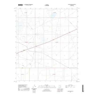
2020 Map of Laguna Gatuna
USGS Topo · Published 2020About this map
Laguna Gatuna dominates the center of this High Plains landscape, situated amidst a cluster of alkaline depressions near the western edge of Lea County. This modern survey details the sparsely settled borderlands where the tiny community of Halfway sits along the intersection of major regional transit routes. The terrain is defined by its series of seasonal lakebeds, including Laguna Tonto to the north and Laguna Plata to the west, which serve as critical landmarks in an otherwise open ranching environment. Local travel is facilitated by a network of rural routes such as Smith Ranch Rd, Tonto Rd, and Goathead Rd, reflecting the expansive scale of land management in southeastern New Mexico. The map provides a precise view of the Public Land Survey System grid across several townships, illustrating the relationship between natural water features and administrative boundaries.
Find a feature on this map
20 named features on this map. Tap any name to fly to it.
Don’t see what you’re looking for? This feature index may not catch every label — zoom into the map to look around manually.
Map Details
Editions of this 2020 Laguna Gatuna Map
This is the sole edition of this map. No revisions or reprints were ever made.
Other maps of this area

1939 · Nash Draw
USGS Topo · 1:62,500

1942 · Clayton Basin
USGS Topo · 1:62,500

1943 · Clayton Basin
USGS Topo · 1:62,500

1943 · Nash Draw
USGS Topo · 1:62,500

1954 · Hobbs
USGS Topo · 1:250,000

1958 · Hobbs
USGS Topo · 1:250,000

1963 · Laguna Gatuna
USGS Topo · 1:62,500

1963 · Hat Mesa
USGS Topo · 1:62,500

1978 · Jal
USGS Topo · 1:100,000

1984 · Lea
USGS Topo · 1:24,000