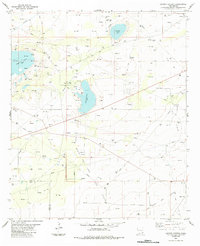
1984 Map of Laguna Gatuna
USGS Topo · Published 1984About this map
Laguna Gatuna and its neighboring salt lakes dominate this arid basin on the boundary between Lea and Eddy Counties in southeastern New Mexico. In the mid-1980s, the landscape was defined by an extensive network of resource extraction, with a dense grid of drill holes, oil wells, and gas wells marking the development of the local Oil Field and Gas Field. The map reveals the infrastructure required to support this industry, including an intricate web of pipelines and aqueducts cutting across the desert floor.
Find a feature on this map
22 named features on this map. Tap any name to fly to it.
Don’t see what you’re looking for? This feature index may not catch every label — zoom into the map to look around manually.
Map Details
Editions of this 1984 Laguna Gatuna Map
This is the sole edition of this map. No revisions or reprints were ever made.
Other maps of this area

1939 · Nash Draw
USGS Topo · 1:62,500

1942 · Clayton Basin
USGS Topo · 1:62,500

1943 · Clayton Basin
USGS Topo · 1:62,500

1943 · Nash Draw
USGS Topo · 1:62,500

1954 · Hobbs
USGS Topo · 1:250,000

1958 · Hobbs
USGS Topo · 1:250,000

1963 · Laguna Gatuna
USGS Topo · 1:62,500

1963 · Hat Mesa
USGS Topo · 1:62,500

1978 · Jal
USGS Topo · 1:100,000

1984 · Lea
USGS Topo · 1:24,000