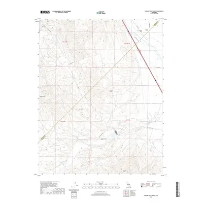
2018 Map of Laguna Seca Ranch
USGS Topo · Published 2018About this map
Laguna Seca Ranch sits at the foot of the Diablo Range, where the steep canyons of the coastal mountains meet the western edge of the Central Valley. This area in western Fresno County is defined by the sharp contrast between the topographic complexity of Wildcat Canyon and Salt Canyon and the engineered precision of the Governor Edmund G Brown California Aqueduct. The landscape transitions from the high peaks of the Panoche Hills down into the Little Panoche Valley, where drainage follows Little Panoche Cr. Agricultural and utility infrastructure, including the First Lift Canal and various pole lines, trace the valley floor, illustrating the heavy modification of the arid terrain for water transport and power distribution at the county line near Merced and Fresno counties.
Find a feature on this map
24 named features on this map. Tap any name to fly to it.
Don’t see what you’re looking for? This feature index may not catch every label — zoom into the map to look around manually.
Map Details
Editions of this 2018 Laguna Seca Ranch Map
This is the sole edition of this map. No revisions or reprints were ever made.
Other maps of this area

1913 · Panoche
USGS Topo · 1:125,000

1920 · Carrisalito Spring
USGS Topo · 1:31,680

1921 · Laguna Seca Ranch
USGS Topo · 1:31,680

1921 · Tierra Loma School
USGS Topo · 1:31,680

1922 · Charleston School
USGS Topo · 1:31,680

1922 · Dos Palos
USGS Topo · 1:31,680

1922 · Ortigalita
USGS Topo · 1:31,680

1923 · Laguna Seca Ranch
USGS Topo · 1:31,680

1923 · Tierra Loma School
USGS Topo · 1:31,680

1923 · Little Panoche
USGS Topo · 1:31,680