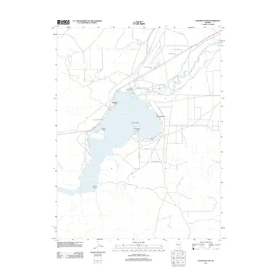
2011 Map of Lahontan Dam
USGS Topo · Published 2011About this map
Lahontan Dam stands as the central engineering feature of this Nevada landscape, controlling the flow of the Carson River to create the expansive Lahontan Reservoir. The high desert shoreline is defined by recreational and geographical markers such as Churchill Beach, Sixmile Beach, and the Lahontan Boat Landing. Within the reservoir itself, Evans Island and protruding landforms like Horsemans Point and Blackbird Point illustrate the varied topography of the basin. The surrounding area features a network of local roads including Farm District Rd and Karen Rd, alongside natural drainage features like Sand Canyon. This 2011 survey reflects the region's primary function as a water management and recreation hub, detailing the modern access points and residential lanes that have developed around the reservoir's eastern and northern fringes.
Find a feature on this map
22 named features on this map. Tap any name to fly to it.
Don’t see what you’re looking for? This feature index may not catch every label — zoom into the map to look around manually.
Map Details
Editions of this 2011 Lahontan Dam Map
This is the sole edition of this map. No revisions or reprints were ever made.
Other maps of this area

1890 · Wadsworth
USGS Topo · 1:125,000

1891 · Wabuska
USGS Topo · 1:125,000

1892 · Wadsworth
USGS Topo · 1:125,000

1894 · Wadsworth
USGS Topo · 1:125,000

1894 · Wabuska
USGS Topo · 1:125,000

1908 · Carson Sink
USGS Topo · 1:250,000

1910 · Carson Sink
USGS Topo · 1:250,000

1951 · Soda Lake
USGS Topo · 1:62,500

1951 · Fallon
USGS Topo · 1:62,500

1957 · Two Tips
USGS Topo · 1:62,500