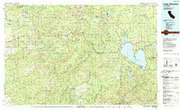
1989 Map of Lake Almanor
USGS Topo · Published 1990About this map
The massive expanse of Lake Almanor dominates this 1980s landscape, serving as a hub for both industry and recreation in the High Sierra. The map details the developed shorelines near Chester and Hamilton Branch, while tracing the critical water management systems of the Butt Valley Reservoir and the North Fork Feather River. To the west, the volcanic topography rises toward the iconic Lassen Peak and Brokeoff Mountain within Lassen Volcanic National Park. The survey illustrates a complex geography of land use, from the timber-rich reaches of the Lassen National Forest to the specialized preservation of the Ishi Wilderness. Smaller mountain communities like Mineral and Butte Meadows are connected by a network of state routes, while the Union Pacific line maintains its path through the rugged canyon country to the south near Belden.
Find a feature on this map
68 named features on this map. Tap any name to fly to it.
Don’t see what you’re looking for? This feature index may not catch every label — zoom into the map to look around manually.
Map Details
Editions of this 1989 Lake Almanor Map
2 editions found
Other maps of this area

1886 · Honey Lake
USGS Topo · 1:250,000

1886 · Lassen Peak
USGS Topo · 1:250,000

1888 · Bidwell Bar
USGS Topo · 1:125,000

1890 · Red Bluff
USGS Topo · 1:250,000

1891 · Bidwell Bar
USGS Topo · 1:125,000

1891 · Chico
USGS Topo · 1:125,000

1891 · Downieville
USGS Topo · 1:125,000

1891 · Honey Lake
USGS Topo · 1:250,000

1892 · Lassen Peak
USGS Topo · 1:250,000

1893 · Chico
USGS Topo · 1:125,000