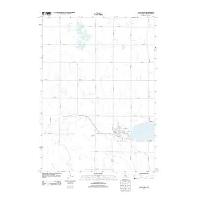
2012 Map of Lake Andes
USGS Topo · Published 2012About this map
Lake Andes dominates the southeastern portion of this 2012 survey, providing a focal point for the surrounding prairie landscape and the community that shares its name. The grid-like arrangement of rural roads, such as 381st Ave and 289th St, reflects the systematic agricultural development characteristic of Charles Mix County. Notable landmarks for genealogical research include the West Lake Andes Cem situated near the northern shores and Lake View Cem further south, both serving as vital records of the area's residents. In the small settlement of Dezera, the intersection of transportation and local commerce is evident near the Lake Andes Municipal Airport. The presence of several smaller water bodies, like Goose Lake, and drainages including Garden Cr and White Swan Cr, highlights the hydrologic patterns of this glaciated terrain.
Find a feature on this map
33 named features on this map. Tap any name to fly to it.
Don’t see what you’re looking for? This feature index may not catch every label — zoom into the map to look around manually.
Map Details
Editions of this 2012 Lake Andes Map
This is the sole edition of this map. No revisions or reprints were ever made.
Other maps of this area

1955 · Mitchell
USGS Topo · 1:250,000

1959 · Mitchell
USGS Topo · 1:250,000

1964 · Ravinia
USGS Topo · 1:24,000

1964 · Lake Andes NW
USGS Topo · 1:24,000

1964 · Fort Randall Dam
USGS Topo · 1:24,000

1964 · Lake Andes SW
USGS Topo · 1:24,000

1964 · Lake Andes
USGS Topo · 1:24,000

1964 · Wagner SW
USGS Topo · 1:24,000
1977 · Wagner SW
USGS Topo · 1:24,000

1977 · Lake Andes NW
USGS Topo · 1:24,000