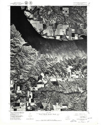
1977 Map of Lake Andes SW
USGS Topo · Published 1979About this map
Francis Case, a large reservoir created by the damming of the Missouri River, dominates the upper half of this 1970s orthophoto. The imagery reveals the stark contrast between the complex, dendritic drainage patterns along the reservoir's southern bluffs and the orderly, rectangular agricultural grid on the northern plateau. To the southeast, the historic site of Fort Randall is visible near the river's edge, highlighting the area's long-standing strategic importance. This map was produced by the Geological Survey in cooperation with the Bureau of Indian Affairs, reflecting the jurisdictional importance of this landscape during the late 20th century. The transportation corridor formed by US Highway 18 and 281 cuts across the lower half of the sheet, providing a primary link between the high plains and the river valley.
Find a feature on this map
6 named features on this map. Tap any name to fly to it.
Don’t see what you’re looking for? This feature index may not catch every label — zoom into the map to look around manually.
Map Details
Editions of this 1977 Lake Andes SW Map
This is the sole edition of this map. No revisions or reprints were ever made.
Other maps of this area

1955 · Mitchell
USGS Topo · 1:250,000

1955 · O'Neill
USGS Topo · 1:250,000

1959 · O'Neill
USGS Topo · 1:250,000

1959 · Mitchell
USGS Topo · 1:250,000

1964 · Campbell Creek
USGS Topo · 1:24,000

1964 · Butte
USGS Topo · 1:24,000

1964 · Lake Andes NW
USGS Topo · 1:24,000

1964 · Fort Randall Dam
USGS Topo · 1:24,000

1964 · Gross
USGS Topo · 1:24,000

1964 · Lake Andes SW
USGS Topo · 1:24,000