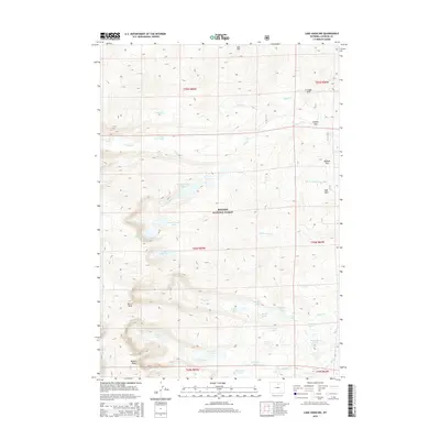
2015 Map of Lake Angeline
USGS Topo · Published 2015About this map
Bighorn National Forest dominates this high-altitude landscape in Johnson County, defined by a complex network of glacial lakes and alpine drainages. The terrain is anchored by significant summits like Darton Peak and Bighorn Peak, which overlook the source waters of N Clear Creek and S Clear Creek. The area is characterized by clusters of named water bodies, including the Seven Brothers Lakes and the isolated Lake Angeline. Broad mountain meadows or "parks" provide distinct navigational markers among the ridges, with names like Triangle Park, Soldier Park, and Buffalo Park indicating areas of lower relief compared to the surrounding peaks. The drainage pattern is intricate, with Middle Clear Creek and Sawmill Creek carving paths through the forest, while smaller pools like Romeo Lake and Ringbone Lake dot the eastern slopes.
Find a feature on this map
41 named features on this map. Tap any name to fly to it.
Don’t see what you’re looking for? This feature index may not catch every label — zoom into the map to look around manually.
Map Details
Editions of this 2015 Lake Angeline Map
This is the sole edition of this map. No revisions or reprints were ever made.
Other maps of this area

1899 · Cloud peak
USGS Topo · 1:125,000

1900 · Fort McKinney
USGS Topo · 1:125,000

1901 · Cloud Peak
USGS Topo · 1:125,000

1903 · Fort McKinney
USGS Topo · 1:125,000

1955 · Sheridan
USGS Topo · 1:250,000

1958 · Sheridan
USGS Topo · 1:250,000

1962 · Sheridan
USGS Topo · 1:250,000
1967 · Willow Park Reservoir
USGS Topo · 1:24,000

1967 · Caribou Creek
USGS Topo · 1:24,000
1967 · Meadowlark Lake
USGS Topo · 1:24,000