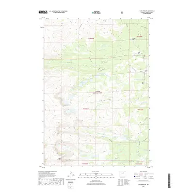
2017 Map of Lake Angeline
USGS Topo · Published 2017About this map
Bighorn National Forest defines this high-elevation landscape in Johnson County, where a dense network of glacial lakes and mountain peaks provides a detailed look at the Bighorn Mountains' interior. Named summits like Darton Peak and Bighorn Peak overlook a system of alpine basins containing Lake Angeline, Lower Frozen Lake, and the chain of Seven Brothers Lakes. The map reveals a land managed for both conservation and recreation, evidenced by several mountain parks including Soldier Park, Buffalo Park, and Triangle Park. These flatter openings in the timber often served as historic encampments or grazing areas. For researchers, the trail system is clearly delineated, with the Solitude Loop, Old Crow, and Sherd Lake Loop providing the primary transit routes through this wilderness. Water drainage patterns are complex, with headwaters like N Clear Cr and Middle Clear Cr flowing through steep-walled canyons.
Find a feature on this map
53 named features on this map. Tap any name to fly to it.
Don’t see what you’re looking for? This feature index may not catch every label — zoom into the map to look around manually.
Map Details
Editions of this 2017 Lake Angeline Map
This is the sole edition of this map. No revisions or reprints were ever made.
Other maps of this area

1899 · Cloud peak
USGS Topo · 1:125,000

1900 · Fort McKinney
USGS Topo · 1:125,000

1901 · Cloud Peak
USGS Topo · 1:125,000

1903 · Fort McKinney
USGS Topo · 1:125,000

1955 · Sheridan
USGS Topo · 1:250,000

1958 · Sheridan
USGS Topo · 1:250,000

1962 · Sheridan
USGS Topo · 1:250,000
1967 · Willow Park Reservoir
USGS Topo · 1:24,000

1967 · Caribou Creek
USGS Topo · 1:24,000
1967 · Meadowlark Lake
USGS Topo · 1:24,000