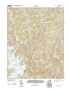
2013 Map of Lake Anna East
USGS Topo · Published 2013About this map
The eastern reaches of Lake Anna dominate the southwestern portion of this landscape, where complex shorelines form distinctive points such as Tyler Point and Browns Point. This 2013 survey of the Virginia interior reflects a rural network of crossroads and small settlements connected by winding secondary routes. Local commerce and community centers are anchored at places like Penneys Crossroad, Chewnings Corner, and Levy. The terrain is deeply etched by a drainage system that includes the Mat River and Arnolds Cr, which feed toward the N Anna River. Historical transit points are preserved through labels for the Smiths Mill Bridge and Davenport Bridge, while modern recreation and residential developments are evident near the water at Brents Landing.
Find a feature on this map
91 named features on this map. Tap any name to fly to it.
Don’t see what you’re looking for? This feature index may not catch every label — zoom into the map to look around manually.
Map Details
Editions of this 2013 Lake Anna East Map
This is the sole edition of this map. No revisions or reprints were ever made.
Other maps of this area

1887 · Spottsylvania
USGS Topo · 1:125,000

1890 · Goochland
USGS Topo · 1:125,000

1892 · Spottsylvania
USGS Topo · 1:125,000

1892 · Goochland
USGS Topo · 1:125,000

1942 · Ladysmith
USGS Topo · 1:31,680

1942 · Partlow
USGS Topo · 1:31,680

1942 · Belmont
USGS Topo · 1:31,680

1942 · Contrary Creek
USGS Topo · 1:31,680

1942 · Spotsylania
USGS Topo · 1:31,680

1942 · Brokenburg
USGS Topo · 1:31,680