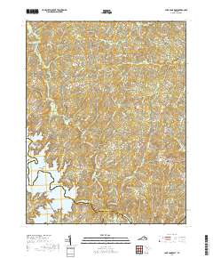
2019 Map of Lake Anna East
USGS Topo · Published 2019About this map
The North Anna River defines the southern reaches of this landscape where the borders of Spotsylvania, Louisa, and Hanover counties meet. Central to the map's geography is the eastern portion of Lake Anna, featuring numerous coves and points such as Valentine Cove, Fishermans Cove, and Burrus Point. The terrain is shaped by the transition from the reservoir's shoreline to the upland agricultural and wooded tracts typical of the Virginia Piedmont.
Find a feature on this map
115 named features on this map. Tap any name to fly to it.
Don’t see what you’re looking for? This feature index may not catch every label — zoom into the map to look around manually.
Map Details
Editions of this 2019 Lake Anna East Map
This is the sole edition of this map. No revisions or reprints were ever made.
Other maps of this area

1887 · Spottsylvania
USGS Topo · 1:125,000

1890 · Goochland
USGS Topo · 1:125,000

1892 · Spottsylvania
USGS Topo · 1:125,000

1892 · Goochland
USGS Topo · 1:125,000

1942 · Ladysmith
USGS Topo · 1:31,680

1942 · Partlow
USGS Topo · 1:31,680

1942 · Belmont
USGS Topo · 1:31,680

1942 · Contrary Creek
USGS Topo · 1:31,680

1942 · Spotsylania
USGS Topo · 1:31,680

1942 · Brokenburg
USGS Topo · 1:31,680