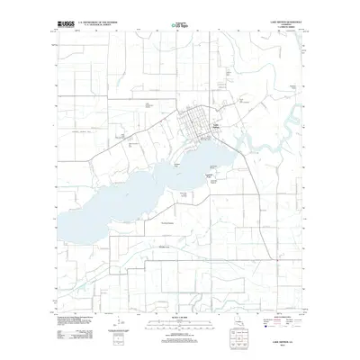
2012 Map of Lake Arthur
USGS Topo · Published 2012About this map
The town of Lake Arthur serves as a focal point for this survey of Jefferson Davis Parish, situated where the Mermentau River flows into the lake. The waterfront infrastructure is highly detailed, highlighting the Talens Marine and Fuel Lake Arthur Dock and the Lake Air Service Airport. The landscape is a complex mix of agricultural land and industrial activity, characterized by extensive fields like Rivillons Pasture and Laurents Pasture alongside established energy sites including the South Lake Arthur Gas Field and West Lake Arthur Oil Field. North of the town center, the Andress Cove Cem and the surrounding Andress Cove area offer important reference points for genealogists. The intricate water management of the region is visible through features like the Klondike Canal and various drainage systems, reflecting the coastal prairie's dependence on controlled irrigation and river access.
Find a feature on this map
82 named features on this map. Tap any name to fly to it.
Don’t see what you’re looking for? This feature index may not catch every label — zoom into the map to look around manually.
Map Details
Editions of this 2012 Lake Arthur Map
This is the sole edition of this map. No revisions or reprints were ever made.
Other maps of this area

1934 · Latania Lake
USGS Topo · 1:24,000

1935 · Latania Lake
USGS Topo · 1:31,680

1946 · Lake Arthur
USGS Topo · 1:31,680

1946 · Mermentau
USGS Topo · 1:31,680

1946 · Jennings
USGS Topo · 1:31,680

1947 · Thornwell
USGS Topo · 1:31,680

1947 · Welsh
USGS Topo · 1:31,680

1949 · Gueydan
USGS Topo · 1:31,680

1952 · Lake Charles
USGS Topo · 1:250,000

1954 · Grand Lake East NW
USGS Topo · 1:31,680