
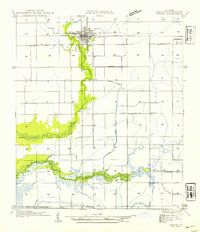
1946 Map of Lake Arthur
USGS Topo · Published 1946About this map
Lake Arthur sits at the heart of this post-war landscape, where the water's edge and the surrounding marshlands of the Mermentau River dictated the development of the region. The map reveals a community defined by its proximity to the water, with prominent landmarks such as Gaithes Point and Laurents Point flanking The Narrows. Transportation and drainage were clearly the lifeblood of the area, evidenced by the Southern Pacific railroad line and an intricate network of waterways including the Klondike Canal and Thornwell Drainage Canal.
Find a feature on this map
25 named features on this map. Tap any name to fly to it.
Don’t see what you’re looking for? This feature index may not catch every label — zoom into the map to look around manually.
Map Details
Editions of this 1946 Lake Arthur Map
This is the sole edition of this map. No revisions or reprints were ever made.
Other maps of this area

1934 · Latania Lake
USGS Topo · 1:24,000

1935 · Latania Lake
USGS Topo · 1:31,680

1946 · Mermentau
USGS Topo · 1:31,680

1946 · Jennings
USGS Topo · 1:31,680

1947 · Thornwell
USGS Topo · 1:31,680

1947 · Welsh
USGS Topo · 1:31,680

1949 · Gueydan
USGS Topo · 1:31,680

1952 · Lake Charles
USGS Topo · 1:250,000

1954 · Grand Lake East NW
USGS Topo · 1:31,680
1954 · Welsh
USGS Topo · 1:31,680