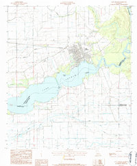
1984 Map of Lake Arthur
USGS Topo · Published 1984About this map
Lake Arthur serves as the focal point of this southwestern Louisiana landscape, where the town of the same name overlooks the wide waters at the confluence with the Mermentau River. The terrain is defined by an intricate network of canals, flumes, and ditches that support the region's agricultural and drainage needs. Significant landmarks like Gaithes Point and Laurents Point frame the lake's eastern reach, while The Narrows constricts the waterway to the west. This 1980s survey illustrates a rural economy reliant on water management and transportation, featuring several pumping stations and the Landing Strip south of the main settlement. Civil engineering and land use are further marked by a Sewage Disp facility and a local Cem, providing granular details for those tracing local development or family history near the Jefferson Davis and Vermilion Parish lines.
Find a feature on this map
18 named features on this map. Tap any name to fly to it.
Don’t see what you’re looking for? This feature index may not catch every label — zoom into the map to look around manually.
Map Details
Editions of this 1984 Lake Arthur Map
This is the sole edition of this map. No revisions or reprints were ever made.
Other maps of this area

1934 · Latania Lake
USGS Topo · 1:24,000

1935 · Latania Lake
USGS Topo · 1:31,680

1946 · Lake Arthur
USGS Topo · 1:31,680

1946 · Mermentau
USGS Topo · 1:31,680

1946 · Jennings
USGS Topo · 1:31,680

1947 · Thornwell
USGS Topo · 1:31,680

1947 · Welsh
USGS Topo · 1:31,680

1949 · Gueydan
USGS Topo · 1:31,680

1952 · Lake Charles
USGS Topo · 1:250,000

1954 · Grand Lake East NW
USGS Topo · 1:31,680