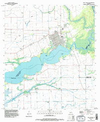
1994 Map of Lake Arthur
USGS Topo · Published 1996About this map
The town of Lake Arthur sits at the northern bend of its namesake lake, where the Mermentau River empties into the basin. This mid-1990s survey illustrates a landscape deeply shaped by water management and resource extraction, with a grid of canals including the Keystone Ditch and Klondike Canal draining the surrounding lowlands. The importance of the waterway is evident in the transition from the open waters of Lake Arthur through the Narrows, framed by landforms such as Gaithes Point and Laurents Point. Beyond the residential areas and the localized Mobile Home Park, the map records the industrial footprint of the region through numerous pumping stations and an extensive network of pipelines. These features, alongside the Thornwell corridor, highlight the intersection of coastal marsh geography and the technical infrastructure required for the area's agricultural and energy sectors.
Find a feature on this map
23 named features on this map. Tap any name to fly to it.
Don’t see what you’re looking for? This feature index may not catch every label — zoom into the map to look around manually.
Map Details
Editions of this 1994 Lake Arthur Map
This is the sole edition of this map. No revisions or reprints were ever made.
Other maps of this area

1934 · Latania Lake
USGS Topo · 1:24,000

1935 · Latania Lake
USGS Topo · 1:31,680

1946 · Lake Arthur
USGS Topo · 1:31,680

1946 · Mermentau
USGS Topo · 1:31,680

1946 · Jennings
USGS Topo · 1:31,680

1947 · Thornwell
USGS Topo · 1:31,680

1947 · Welsh
USGS Topo · 1:31,680

1949 · Gueydan
USGS Topo · 1:31,680

1952 · Lake Charles
USGS Topo · 1:250,000

1954 · Grand Lake East NW
USGS Topo · 1:31,680