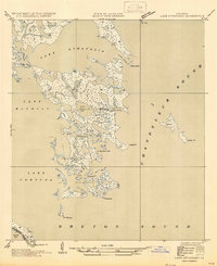
1947 Map of Lake Athanasio
USGS Topo · Published 1947About this map
Lake Athanasio and the surrounding marshlands of St Bernard Parish are depicted here prior to significant coastal erosion and modern hydrological changes. Based on aerial photography and a 1935 field examination, the survey documents a complex network of wetlands where Chandeleur Sound meets the interior basins. Waterways like Canal Pecal and Mulatto Bayou thread through the unstable geography, illustrating the fluid border between the Gulf and the delta. Further south, the boundary between St Bernard Parish and Plaquemines Parish crosses through Black Bay, a region defined by landmarks such as Mozambique Pt and Pt Fortuna. Significant water bodies including Lake Machias and Seven Dollar Bay dominate the central portion of the sheet, providing a primary record of the coastal landforms and named points like Coon Nest I and Fiddler Pt during the mid-1940s.
Find a feature on this map
23 named features on this map. Tap any name to fly to it.
Don’t see what you’re looking for? This feature index may not catch every label — zoom into the map to look around manually.
Map Details
Editions of this 1947 Lake Athanasio Map
This is the sole edition of this map. No revisions or reprints were ever made.
Other maps of this area

1893 · La Fortuna
USGS Topo · 1:62,500

1893 · Shell Beach
USGS Topo · 1:62,500

1893 · Dime
USGS Topo · 1:62,500

1895 · Bodreau
USGS Topo · 1:62,500

1935 · Morgan Harbor
USGS Topo · 1:31,680

1935 · Lake Athanasio
USGS Topo · 1:31,680

1935 · Lake Calebasse
USGS Topo · 1:31,680

1939 · Shell Beach
USGS Topo · 1:62,500

1941 · Black Bay
USGS Topo · 1:62,500

1941 · Shell Beach
USGS Topo · 1:62,500