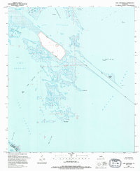
1994 Map of Lake Athanasio
USGS Topo · Published 1995About this map
The Mississippi River Gulf Outlet bisects this coastal landscape, cutting a straight industrial path through the marshy transition between Lake Athanasio and Breton Sound. This mid-1990s record of the St. Bernard Parish wetlands shows a complex network of oil and gas infrastructure, including the Half Moon Lake Oil Field and numerous offshore platforms, interspersed with tidal bayous like Bayou Pointe-en-Pointe and Bayou Frenepiquant.
Find a feature on this map
33 named features on this map. Tap any name to fly to it.
Don’t see what you’re looking for? This feature index may not catch every label — zoom into the map to look around manually.
Map Details
Editions of this 1994 Lake Athanasio Map
This is the sole edition of this map. No revisions or reprints were ever made.
Other maps of this area

1893 · La Fortuna
USGS Topo · 1:62,500

1893 · Shell Beach
USGS Topo · 1:62,500

1893 · Dime
USGS Topo · 1:62,500

1895 · Bodreau
USGS Topo · 1:62,500

1935 · Morgan Harbor
USGS Topo · 1:31,680

1935 · Lake Athanasio
USGS Topo · 1:31,680

1935 · Lake Calebasse
USGS Topo · 1:31,680

1939 · Shell Beach
USGS Topo · 1:62,500

1941 · Black Bay
USGS Topo · 1:62,500

1941 · Shell Beach
USGS Topo · 1:62,500