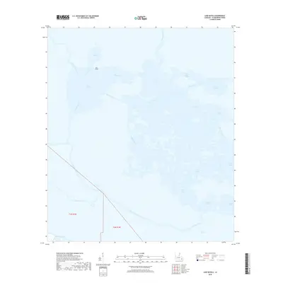
2018 Map of Lake Batola
USGS Topo · Published 2018About this map
River aux Chenes snakes through the marshlands of eastern Plaquemines Parish, defining a landscape dominated by shifting water and coastal estuaries. This 2018 survey reveals a complex network of bayous and lagoons, including Grand Lake and Petit Lake, which break up the low-lying terrain known as The Garigue. The map documents a fragile coastal environment where named water bodies like Little Lake Batola and Lake Batola provide the primary geographical structure. Significant waterways like Bayou Long and Bayou Batola facilitate movement through the wetlands, while man-made features such as the Back Levee Canal indicate the ongoing human effort to manage water levels along the edges of the marsh. The absence of traditional road networks highlights the maritime character of this region, where life is governed by the tides and the reach of the Gulf of Mexico through inlets like Pointe Fienne Bay.
Find a feature on this map
27 named features on this map. Tap any name to fly to it.
Don’t see what you’re looking for? This feature index may not catch every label — zoom into the map to look around manually.
Map Details
Editions of this 2018 Lake Batola Map
This is the sole edition of this map. No revisions or reprints were ever made.
Other maps of this area

1891 · Pointe a La Hache
USGS Topo · 1:62,500

1892 · St. Bernard
USGS Topo · 1:62,500

1892 · Pointe a La Hache
USGS Topo · 1:62,500

1893 · Shell Beach
USGS Topo · 1:62,500

1893 · Dime
USGS Topo · 1:62,500

1935 · Delacroix
USGS Topo · 1:31,680

1935 · Lake Batola
USGS Topo · 1:31,680

1939 · Shell Beach
USGS Topo · 1:62,500

1939 · Pointe a La Hache
USGS Topo · 1:62,500
1940 · Belle Chasse
USGS Topo · 1:31,680