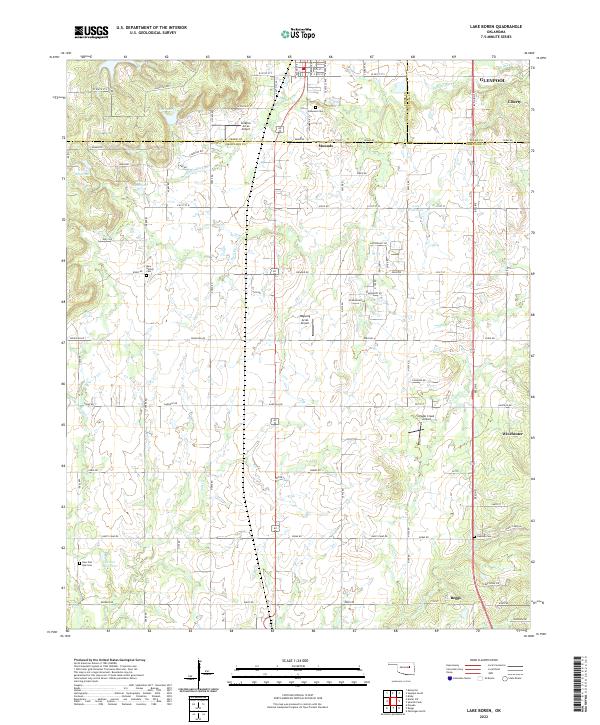
2022 Map of Lake Boren
USGS Topo · Published 2022About this map
Mounds and Beggs anchor this landscape along the border of Creek, Okmulgee, and Tulsa Counties. The terrain is defined by a dense network of small waterways including Middle Duck Cr, Salt Cr, and Eagle Cr, which feed several unnamed reservoirs. Aviation is a prominent theme in the local infrastructure, with private and regional facilities such as Aviation Acres Airport, Ragwing Acres Airport, and Eagle Creek Airport distributed across the prairie. For genealogists and local historians, several burial grounds provide essential reference points, including Oakwood Cem near Mounds and New Bethel Cem further south. The transportation corridor follows the Beeline, a primary north-south artery connecting the northern residential expansion of Glenpool with the more rural southern reaches near Winchester. Small water bodies like Lake Boren reflect the characteristic land use of this Oklahoma region, where water management is critical to both agriculture and suburban development.
Find a feature on this map
74 named features on this map. Tap any name to fly to it.
Don’t see what you’re looking for? This feature index may not catch every label — zoom into the map to look around manually.
Map Details
Editions of this 2022 Lake Boren Map
This is the sole edition of this map. No revisions or reprints were ever made.
Other maps of this area

1896 · Okmulgee
USGS Topo · 1:125,000

1900 · Okmulgee
USGS Topo · 1:125,000

1901 · Nuyaka
USGS Topo · 1:125,000

1914 · Kiefer
USGS Topo · 1:62,500

1916 · Kiefer
USGS Topo · 1:62,500

1946 · Fort Smith
USGS Topo · 1:250,000

1954 · Oklahoma City
USGS Topo · 1:250,000
1957 · Bixby
USGS Topo · 1:24,000

1957 · Oklahoma City
USGS Topo · 1:250,000
1958 · Sapulpa South
USGS Topo · 1:24,000