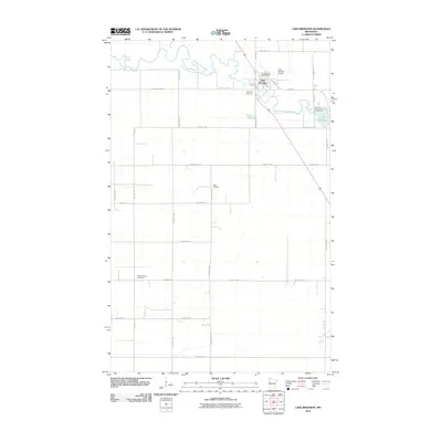
2010 Map of Lake Bronson
USGS Topo · Published 2010About this map
The Lake Bronson community serves as the focal point of this Kittson County landscape, situated near the winding South Branch Two Rivers. The map documents the vital water management and infrastructure of the region, anchored by the Bronson Lake Dam which maintains the reservoir. Local genealogy is well-supported by several distinct burial sites across the township, including Riverside Cemetery near the town site, the central Vagle Cemetery, and East Emmaus Cemetery to the west. This survey illustrates a highly organized rural grid, where numerous township roads like Twp Hwy T-79 and Twp Hwy T-106 provide access to the vast agricultural acreage surrounding the settlement. Civic and transport hubs are clearly marked, from the Lake Bronson Post Office on E Main St to the Lake Bronson Airport situated just east of the river's upper reaches.
Find a feature on this map
33 named features on this map. Tap any name to fly to it.
Don’t see what you’re looking for? This feature index may not catch every label — zoom into the map to look around manually.
Map Details
Editions of this 2010 Lake Bronson Map
This is the sole edition of this map. No revisions or reprints were ever made.
Other maps of this area

1918 · Hemmington
USGS Topo · 1:62,500

1939 · Kennedy
USGS Topo · 1:62,500

1941 · Kennedy
USGS Topo · 1:62,500

1941 · Hallock
USGS Topo · 1:62,500

1952 · Thief River Falls
USGS Topo · 1:250,000

1956 · Thief River Falls
USGS Topo · 1:250,000

1956 · Karlstad
USGS Topo · 1:62,500

1957 · Thief River Falls
USGS Topo · 1:250,000

1966 · Skull Lake SE
USGS Topo · 1:24,000
1966 · Skull Lake SW
USGS Topo · 1:24,000