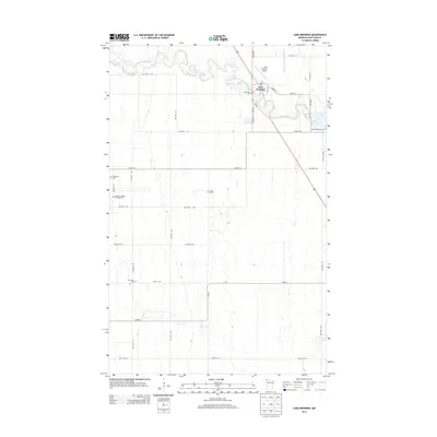
2013 Map of Lake Bronson
USGS Topo · Published 2013About this map
Lake Bronson sits at the northern edge of this Kittson County landscape, positioned where the South Branch Two Rivers meanders through the prairie. The map reveals a high concentration of small, family-associated burial sites and cemeteries that speak to the Scandinavian heritage and homesteading history of this corner of Minnesota. Notable sites include the Mandie Johnson Farm Burials, Johansson Cem, and the Bronson Pioneer Cem located southeast of the main settlement. The terrain is defined by a grid of township roads and significant drainage infrastructure, such as State Ditch Number Forty-eight, which was essential for managing the flat, low-lying lands of the Red River Valley region. Lake Bronson Airport and the local Po serve as central landmarks for the community in this modern survey.
Find a feature on this map
36 named features on this map. Tap any name to fly to it.
Don’t see what you’re looking for? This feature index may not catch every label — zoom into the map to look around manually.
Map Details
Editions of this 2013 Lake Bronson Map
This is the sole edition of this map. No revisions or reprints were ever made.
Other maps of this area

1918 · Hemmington
USGS Topo · 1:62,500

1939 · Kennedy
USGS Topo · 1:62,500

1941 · Kennedy
USGS Topo · 1:62,500

1941 · Hallock
USGS Topo · 1:62,500

1952 · Thief River Falls
USGS Topo · 1:250,000

1956 · Thief River Falls
USGS Topo · 1:250,000

1956 · Karlstad
USGS Topo · 1:62,500

1957 · Thief River Falls
USGS Topo · 1:250,000

1966 · Skull Lake SE
USGS Topo · 1:24,000
1966 · Skull Lake SW
USGS Topo · 1:24,000