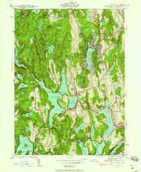
1943 Map of Lake Carmel
USGS Topo · Published 1958About this map
Carmel and its surrounding townships reflect a landscape dominated by the complex New York water supply system and early 20th-century recreational development. The central portion of this survey is defined by the expansive West Branch Reservoir and Lake Gleneida, part of the Croton watershed infrastructure that reshaped local geography. Near the eastern shore of Lake Carmel, densely plotted residential blocks signify the era's transition from rural farmland to seasonal and suburban lakeside communities.
Find a feature on this map
57 named features on this map. Tap any name to fly to it.
Don’t see what you’re looking for? This feature index may not catch every label — zoom into the map to look around manually.
Map Details
Editions of this 1943 Lake Carmel Map
This is the sole edition of this map. No revisions or reprints were ever made.
Other maps of this area

1892 · West Point
USGS Topo · 1:62,500

1892 · Carmel
USGS Topo · 1:62,500

1893 · Carmel
USGS Topo · 1:62,500

1893 · Clove
USGS Topo · 1:62,500

1893 · Poughkeepsie
USGS Topo · 1:62,500

1894 · West Point
USGS Topo · 1:62,500

1894 · Clove
USGS Topo · 1:62,500

1894 · Carmel
USGS Topo · 1:62,500

1894 · Poughkeepsie
USGS Topo · 1:62,500

1898 · Clove
USGS Topo · 1:62,500