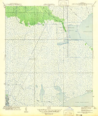
1942 Map of Lake Cataouatche West
USGS Topo · Published 1942About this map
Lake Cataouatche and Lake Salvador dominate this coastal Louisiana landscape, illustrating the intricate hydrology of the St. Charles Parish wetlands in the early 1940s. The map reveals an era of significant environmental modification, most notably through the New Orleans Netherlands Drainage District and the industrial infrastructure of the Louisiana Cypress Lumber Canal. These man-made channels intersect a network of natural watercourses including Bayou Cypriere Longue, Bayou Bois Piquant, and Bayou de Sauce. The terrain is characterized by expansive marshlands occasionally broken by features such as Bouquet des Chenes. This survey reflects the intersection of natural deltaic bayous with the deliberate efforts of the drainage and timber industries to navigate and manage the watery terrain south of the Mississippi River.
Find a feature on this map
15 named features on this map. Tap any name to fly to it.
Don’t see what you’re looking for? This feature index may not catch every label — zoom into the map to look around manually.
Map Details
Editions of this 1942 Lake Cataouatche West Map
This is the sole edition of this map. No revisions or reprints were ever made.
Other maps of this area

1891 · Hahnville
USGS Topo · 1:62,500

1891 · New Orleans
USGS Topo · 1:62,500

1892 · Barataria
USGS Topo · 1:62,500

1892 · Cut-Off
USGS Topo · 1:62,500

1932 · New Orleans NW
USGS Topo · 1:31,680

1932 · New Orleans SW
USGS Topo · 1:31,680

1932 · Hahnville NW
USGS Topo · 1:31,680

1932 · Hahnville SW
USGS Topo · 1:31,680

1932 · Hahnville NE
USGS Topo · 1:31,680

1935 · Luling
USGS Topo · 1:31,680