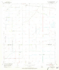
1955 Map of Lake Charles SE
USGS Topo · Published 1973About this map
The settlement of Holmwood sits at the northern edge of this coastal prairie landscape, where the Southern Pacific railroad line cuts across the terrain. This mid-century survey illustrates the intricate water management required in the lowlands of Calcasieu Parish and Cameron Parish, dominated by features such as the Government Ditch, Indian Bayou Levee, and the North Canal. These man-made alterations to the landscape speak to the agricultural and industrial efforts to tame the wetlands south of Lake Charles.
Find a feature on this map
11 named features on this map. Tap any name to fly to it.
Don’t see what you’re looking for? This feature index may not catch every label — zoom into the map to look around manually.
Map Details
Editions of this 1955 Lake Charles SE Map
3 editions found
Other maps of this area

1932 · Lake Charles NE
USGS Topo · 1:31,680

1932 · Lake Charles NW
USGS Topo · 1:31,680

1932 · Lake Charles SW
USGS Topo · 1:31,680

1932 · Lake Charles SE
USGS Topo · 1:31,680

1934 · Lake Misere
USGS Topo · 1:24,000

1934 · Sweet Lake
USGS Topo · 1:24,000

1934 · Boudreaux Lake
USGS Topo · 1:24,000

1935 · Sweet Lake
USGS Topo · 1:31,680

1935 · Lake Misere
USGS Topo · 1:31,680

1935 · Boudreaux Lake
USGS Topo · 1:31,680