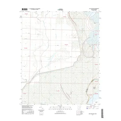
2017 Map of Lake Cheatham
USGS Topo · Published 2017About this map
Lake Cheatham and the winding course of the Arkansas River dominate this 2017 study of the riparian border between Arkansas and Mississippi. This low-lying delta landscape is defined by its complex hydrography, where the main channel meets the Mississippi River near Monterey Bend. The area is a labyrinth of backwaters and oxbows, including Little Jefferson Lake, Eagles Nest Lake, and the expansive Swan Lake. Landforms like Big Island and Wells Point illustrate the shifting nature of the river's path over time, while man-made features such as Canal Number 66 and Canal Number 81 indicate efforts to manage the wetlands. A network of rural routes, including Great River Road and Wargo Road, provide access to the various landings and agricultural tracts that dot the shoreline of Red Fork Bayou and Sutton Bayou.
Find a feature on this map
51 named features on this map. Tap any name to fly to it.
Don’t see what you’re looking for? This feature index may not catch every label — zoom into the map to look around manually.
Map Details
Editions of this 2017 Lake Cheatham Map
This is the sole edition of this map. No revisions or reprints were ever made.
Other maps of this area

1933 · Lamont
USGS Topo · 1:62,500

1935 · Red Fork
USGS Topo · 1:62,500

1936 · McGehee
USGS Topo · 1:62,500

1937 · McGehee
USGS Topo · 1:62,500

1939 · Big Island
USGS Topo · 1:62,500

1939 · Lamont
USGS Topo · 1:62,500

1953 · Greenwood
USGS Topo · 1:250,000

1955 · McGehee
USGS Topo · 1:62,500

1956 · Greenwood
USGS Topo · 1:250,000
1969 · Watson
USGS Topo · 1:24,000