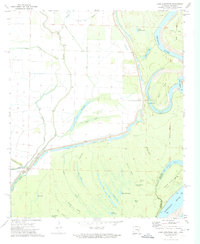
1972 Map of Lake Cheatham
USGS Topo · Published 1974About this map
The Arkansas River and Mississippi River converge in this 1970s landscape, where a complex network of bayous, sloughs, and oxbow lakes defines the Arkansas delta. The map details the aquatic geography of Big Island and Wells Point, illustrating how the rivers have shaped the land with features like Dead Lake and the serpentine Piling Brake. Land use is closely tied to these waters, with engineering works such as the Levee and various drainage systems including Canal No 67 and Canal No 66 attempting to manage the seasonal flow. Small landmarks like St Marys Ch and Wargo Landing provide evidence of local navigation and community focal points near the water's edge. This environment, captured before further modern alterations, shows a hybrid of natural riverine processes and agricultural reclamation efforts through sloughs like Hogpen Slough and Horsehead Slough.
Find a feature on this map
40 named features on this map. Tap any name to fly to it.
Don’t see what you’re looking for? This feature index may not catch every label — zoom into the map to look around manually.
Map Details
Editions of this 1972 Lake Cheatham Map
This is the sole edition of this map. No revisions or reprints were ever made.
Other maps of this area

1933 · Lamont
USGS Topo · 1:62,500

1935 · Red Fork
USGS Topo · 1:62,500

1936 · McGehee
USGS Topo · 1:62,500

1937 · McGehee
USGS Topo · 1:62,500

1939 · Big Island
USGS Topo · 1:62,500

1939 · Lamont
USGS Topo · 1:62,500

1953 · Greenwood
USGS Topo · 1:250,000

1955 · McGehee
USGS Topo · 1:62,500

1956 · Greenwood
USGS Topo · 1:250,000
1969 · Watson
USGS Topo · 1:24,000