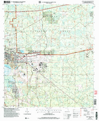
2005 Map of Lake City East
USGS Topo · Published 2006About this map
Watertown and the eastern fringes of Lake City dominate this Florida landscape, where urban development meets the sprawling timberlands of the Osceola National Forest. The map illustrates a mid-century infrastructure that has evolved into a modern regional hub, centered around the Lake City Municipal Airport and the USFS Tanker Base. For genealogists and local historians, several landmarks offer deep connections to the community's past, including Bethlehem Cem, Price Creek Cem, and Tuvine Cem, alongside local congregations like Watertown Ch and Bethel Ch.
Find a feature on this map
46 named features on this map. Tap any name to fly to it.
Don’t see what you’re looking for? This feature index may not catch every label — zoom into the map to look around manually.
Map Details
Editions of this 2005 Lake City East Map
This is the sole edition of this map. No revisions or reprints were ever made.
Other maps of this area

1954 · Valdosta
USGS Topo · 1:250,000

1958 · Valdosta
USGS Topo · 1:250,000

1959 · Valdosta
USGS Topo · 1:250,000

1961 · Deep Creek
USGS Topo · 1:24,000

1961 · White Springs East
USGS Topo · 1:24,000

1962 · Lake City East
USGS Topo · 1:24,000

1963 · Olustee
USGS Topo · 1:24,000

1963 · Ellisville
USGS Topo · 1:24,000

1963 · Columbia
USGS Topo · 1:24,000

1963 · Lake City West
USGS Topo · 1:24,000