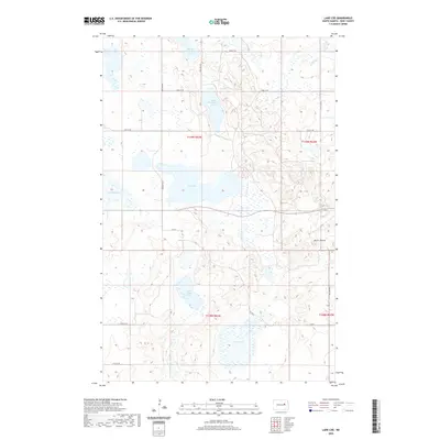
2020 Map of Lake Coe
USGS Topo · Published 2020About this map
Lake Coe and a complex network of glacial wetlands dominate this Eddy County landscape, reflecting the prairie pothole region's distinctive hydrology. The 2020 terrain is defined by numerous water bodies including North Washington Lake, South Washington Lake, and the small Medicine Lake to the west. This area shows a strictly organized section-line road grid, where routes like 23rd St NE and 87th Ave NE intersect across the open plains. In the southeast, the topography rises toward the landmark known as Devils Thumb, situated near Cherry Lake. The map illustrates a rural environment where land use is closely tied to the shifting water levels of these varied basins, such as South Twin Lake, which are characteristic of this portion of North Dakota.
Find a feature on this map
23 named features on this map. Tap any name to fly to it.
Don’t see what you’re looking for? This feature index may not catch every label — zoom into the map to look around manually.
Map Details
Editions of this 2020 Lake Coe Map
This is the sole edition of this map. No revisions or reprints were ever made.
Other maps of this area

1928 · Tokio
USGS Topo · 1:62,500

1930 · Hamar
USGS Topo · 1:62,500

1931 · Tokio
USGS Topo · 1:62,500

1944 · Brantford
USGS Topo · 1:62,500

1946 · Brantford
USGS Topo · 1:62,500

1949 · Grace City
USGS Topo · 1:24,000

1950 · Grace City
USGS Topo · 1:24,000

1950 · Brantford NE
USGS Topo · 1:24,000
1951 · Horseshoe Lake
USGS Topo · 1:24,000
1951 · Tokio
USGS Topo · 1:62,500