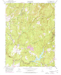
1949 Map of Lake Combie
USGS Topo · Published 1977About this map
Wolf Creek and the Bear River define the hydraulic landscape of this region along the Nevada and Placer County line. The terrain is marked by an extensive network of water management features, including the Tarr Ditch, Cunningham Ditch, and a Siphon, reflecting the area's history of resource extraction and irrigation. Notable industrial and civic sites include the Stockton Hill Mine and the State Forestry Guard Sta, while the educational needs of the era are represented by Limekiln Sch.
Find a feature on this map
45 named features on this map. Tap any name to fly to it.
Don’t see what you’re looking for? This feature index may not catch every label — zoom into the map to look around manually.
Map Details
Editions of this 1949 Lake Combie Map
4 editions found
Other maps of this area

1888 · Smartsville
USGS Topo · 1:125,000

1891 · Sacramento
USGS Topo · 1:125,000

1891 · Colfax
USGS Topo · 1:125,000

1891 · Smartsville
USGS Topo · 1:125,000

1891 · Placerville
USGS Topo · 1:125,000

1892 · Sacramento
USGS Topo · 1:125,000

1892 · Placerville
USGS Topo · 1:125,000

1892 · Smartsville
USGS Topo · 1:125,000

1892 · Colfax
USGS Topo · 1:125,000

1893 · Placerville
USGS Topo · 1:125,000
Featured Places
- Higgins Corner, CA
- Sierra Knoll Estates, CA
- Cherry Creek Acres, CA
- Willaura Estates, CA
- Alta Sierra Estates, CA