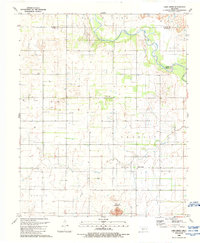
1989 Map of Lake Creek
USGS Topo · Published 1989About this map
North Fork Red River cuts a wide, serpentine path through the northern landscape of this 1989 survey, where the borders of Beckham, Greer, and Kiowa counties converge. The terrain transitions from the alluvial plains of the river valley to the more varied elevations of the Granite Mountains and the landform known as Dill. This area is defined by a dense network of energy and agricultural infrastructure, evidenced by numerous Gas Wells, Oil Wells, and a prominent Windmill. The small settlement of Lake Creek sits near the namesake waterway, accompanied by vital local utilities like a Radio Tower and Substation. For genealogists, the Pleasant Valley Cem provides a specific point of interest for tracing family history in this rural Oklahoma landscape. The presence of a Quarry and scattered water tanks further underscores the region's reliance on both extractive industry and ranching during the late 20th century.
Find a feature on this map
23 named features on this map. Tap any name to fly to it.
Don’t see what you’re looking for? This feature index may not catch every label — zoom into the map to look around manually.
Map Details
Editions of this 1989 Lake Creek Map
This is the sole edition of this map. No revisions or reprints were ever made.
Other maps of this area

1955 · Lawton
USGS Topo · 1:250,000

1955 · Clinton
USGS Topo · 1:250,000

1957 · Clinton
USGS Topo · 1:250,000

1961 · Willow
USGS Topo · 1:62,500

1961 · Retrop
USGS Topo · 1:62,500

1971 · Mangum North
USGS Topo · 1:24,000

1971 · Granite
USGS Topo · 1:24,000

1971 · Lake Altus
USGS Topo · 1:24,000

1985 · Elk City
USGS Topo · 1:100,000

1985 · Altus
USGS Topo · 1:100,000