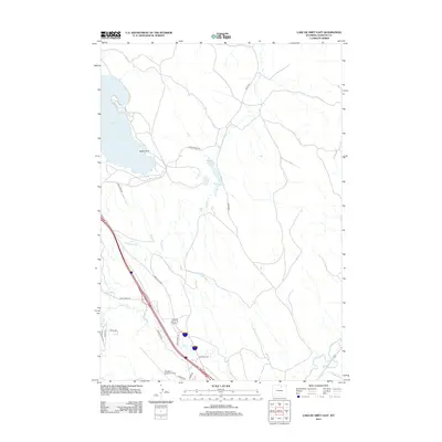
2012 Map of Lake De Smet East
USGS Topo · Published 2012About this map
Lake De Smet and its surrounding water management systems anchor this high-plains landscape in Johnson County. The map details an extensive network of irrigation and drainage features, including the Lake Desmet Canal and the Redman Ditch, which trace the movement of water across the prairie to support local agriculture. Prominent landmarks such as Seney Point jut into the lake, while the Moore Reservoir provides further storage along Boxelder Creek. To the south, the Johnson County Airport serves as a modern transportation hub alongside Interstate 90. The drainage patterns of Clear Creek, Rock Creek, and Sand Creek reveal the natural topography that dictated early ranching routes, many of which are now preserved as rural roads like M&M Ranch Rd and Stage Trail Rd.
Find a feature on this map
24 named features on this map. Tap any name to fly to it.
Don’t see what you’re looking for? This feature index may not catch every label — zoom into the map to look around manually.
Map Details
Editions of this 2012 Lake De Smet East Map
This is the sole edition of this map. No revisions or reprints were ever made.
Other maps of this area

1900 · Fort McKinney
USGS Topo · 1:125,000

1903 · Fort McKinney
USGS Topo · 1:125,000

1909 · Sheridan
USGS Topo · 1:125,000

1911 · Sheridan
USGS Topo · 1:125,000

1955 · Sheridan
USGS Topo · 1:250,000

1958 · Sheridan
USGS Topo · 1:250,000

1962 · Sheridan
USGS Topo · 1:250,000

1967 · Lake De Smet West
USGS Topo · 1:24,000
1967 · Banner
USGS Topo · 1:24,000
1967 · North Ridge
USGS Topo · 1:24,000