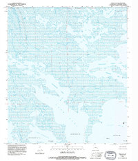
1994 Map of Lake Eloi
USGS Topo · Published 1995About this map
Half Moon Lake Oil Field and the Eloi Bay Oil Field dominate this coastal Louisiana landscape, where the extraction industry interfaces with a complex marshland environment. In this 1990s survey, the terrain is characterized by a labyrinth of lagoons, passes, and bays where no point rises more than five feet above sea level. This is a purely maritime and industrial geography, defined by the Lake Athanasio Gas Field and several offshore platforms. Navigational channels like China Pass, Joe Shiman Pass, and Treasure Pass cut through the marsh, linking larger water bodies such as Lake Eloi and Christmas Camp Lake. The map serves as a vital record of the fragile coastline and the Bayou Petre drainage system before decades of erosion further altered these tidal reaches.
Find a feature on this map
26 named features on this map. Tap any name to fly to it.
Don’t see what you’re looking for? This feature index may not catch every label — zoom into the map to look around manually.
Map Details
Editions of this 1994 Lake Eloi Map
This is the sole edition of this map. No revisions or reprints were ever made.
Other maps of this area

1893 · La Fortuna
USGS Topo · 1:62,500

1893 · Shell Beach
USGS Topo · 1:62,500

1893 · Dime
USGS Topo · 1:62,500

1895 · Bodreau
USGS Topo · 1:62,500

1935 · Morgan Harbor
USGS Topo · 1:31,680

1935 · Lake Athanasio
USGS Topo · 1:31,680

1935 · Lake Calebasse
USGS Topo · 1:31,680

1939 · Shell Beach
USGS Topo · 1:62,500

1941 · Black Bay
USGS Topo · 1:62,500

1941 · Shell Beach
USGS Topo · 1:62,500