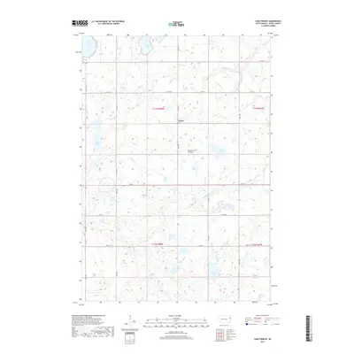
2017 Map of Lake Francis
USGS Topo · Published 2017About this map
Moritz stands as the primary settlement within this section of Deuel County, situated on the prominent glacial upland known as the Coteau des Prairies. This high plateau landscape is defined by its complex drainage and numerous glacial depressions, creating a dense network of prairie lakes and seasonal wetlands. Significant water bodies including Lake Alice, Lone Tree Lake, and Rush Lake dominate the northern and western sections, while the namesake Lake Francis lies further east. The drainage pattern is split between several winding watercourses, including Monighan Cr, Crow Cr, and the upper reaches of the Br Lac qui Parle River. A rigid grid of section-line roads, such as Co RD 309 and 180th St, provides the only structure across this open, rolling terrain, reflecting the enduring township-and-range land management of the Great Plains.
Find a feature on this map
30 named features on this map. Tap any name to fly to it.
Don’t see what you’re looking for? This feature index may not catch every label — zoom into the map to look around manually.
Map Details
Editions of this 2017 Lake Francis Map
This is the sole edition of this map. No revisions or reprints were ever made.
Other maps of this area

1953 · Watertown
USGS Topo · 1:250,000

1958 · Watertown
USGS Topo · 1:250,000

1967 · Gary
USGS Topo · 1:24,000

1967 · Canby NW
USGS Topo · 1:24,000

1967 · Gary NW
USGS Topo · 1:24,000

1970 · Brandt
USGS Topo · 1:24,000

1970 · Clear Lake South
USGS Topo · 1:24,000

1973 · Tunerville
USGS Topo · 1:24,000
1973 · Lake Francis
USGS Topo · 1:24,000
1973 · Clear Lake NE
USGS Topo · 1:24,000