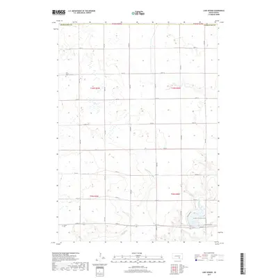
2017 Map of Lake George
USGS Topo · Published 2017About this map
Lake George and its surrounding wetlands anchor this prairie landscape in southern South Dakota near the border of Charles Mix Co. The 2017 survey reveals a strictly organized section-line road network, including 269th St and 361st Ave, which service the agricultural parcels of t100n r69w and t100n r68w. Local history is preserved at the Lake George Cem and the Castalia Cem, both located near the winding course of Castalia Cr. In the southeastern corner, the terrain shifts toward Lake Platte and the Platte Creek drainage. This area includes Henry Cool Memorial Park, accessed via Platte Lake Rd, showing the convergence of conservation and recreation in a region defined by its hydrological features and large-scale township divisions.
Find a feature on this map
32 named features on this map. Tap any name to fly to it.
Don’t see what you’re looking for? This feature index may not catch every label — zoom into the map to look around manually.
Map Details
Editions of this 2017 Lake George Map
This is the sole edition of this map. No revisions or reprints were ever made.
Other maps of this area

1955 · Mitchell
USGS Topo · 1:250,000

1959 · Mitchell
USGS Topo · 1:250,000

1971 · Academy
USGS Topo · 1:24,000

1971 · Lucas SE
USGS Topo · 1:24,000

1979 · Cedar Grove Colony
USGS Topo · 1:24,000

1979 · Castalia
USGS Topo · 1:24,000
1979 · Bovee
USGS Topo · 1:24,000

1979 · Eagle
USGS Topo · 1:24,000

1979 · Lake George
USGS Topo · 1:24,000
1979 · Platte
USGS Topo · 1:24,000
Featured Places
- Torrey Lake Township, SD
- Lake George Township, SD
- Forbes Township, SD
- Pleasant Grove Township, SD
- Castalia Township, SD