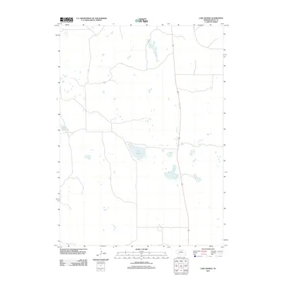
2011 Map of Lake George
USGS Topo · Published 2011About this map
The northern Sandhills of Rock County define this landscape, where natural basins collect water to form distinctive wetlands and lakes. Lake George serves as a central hydrological feature, joined to the west by Carp Lake. These water bodies are part of a larger network of unnamed ponds and marshes characteristic of the region's topography. Human infrastructure is minimal, represented primarily by the north-south corridor of Highway 183, which provides the main transit route through the sparse ranching country. The map illustrates the specialized land use in this part of Nebraska, where the terrain is dominated by the natural drainage patterns of the prairie rather than dense settlement or industrial development.
Find a feature on this map
3 named features on this map. Tap any name to fly to it.
Don’t see what you’re looking for? This feature index may not catch every label — zoom into the map to look around manually.
Map Details
Editions of this 2011 Lake George Map
This is the sole edition of this map. No revisions or reprints were ever made.
Other maps of this area

1955 · O'Neill
USGS Topo · 1:250,000

1959 · O'Neill
USGS Topo · 1:250,000

1969 · O'Neill
USGS Topo · 1:250,000

1981 · Stonehouse Ranch NW
USGS Topo · 1:24,000

1981 · Paramount Valley
USGS Topo · 1:24,000

1981 · Rose
USGS Topo · 1:24,000
1982 · Linke Lake
USGS Topo · 1:24,000

1982 · Hagan Lake NE
USGS Topo · 1:24,000

1982 · Stockdale Lake
USGS Topo · 1:24,000
1982 · Lake George
USGS Topo · 1:24,000