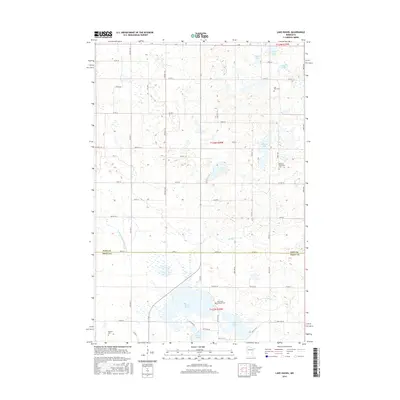
2016 Map of Lake Hassel
USGS Topo · Published 2016About this map
The border of Pope and Swift Counties divides this central Minnesota landscape, where the prairie is defined by a dense concentration of glacial basins and agricultural drainage. Significant water bodies like Lake Hassel and Swan Lake dominate the central terrain, while County Ditch Number Thirteen illustrates the extensive 21st-century water management necessary for regional farming. The map is a valuable resource for genealogists, as it preserves the locations of several burial grounds tied to early Scandinavian and European settlement, including the Lake Hazel Lutheran Cem, East Zion Cem, and the Ellerson-Mortenson Cem. The road network follows a strict sectional grid, from the larger County Highway 9 to local township routes like Twp Rd T-222, showing the enduring footprint of the Public Land Survey System in this rural corridor.
Find a feature on this map
59 named features on this map. Tap any name to fly to it.
Don’t see what you’re looking for? This feature index may not catch every label — zoom into the map to look around manually.
Map Details
Editions of this 2016 Lake Hassel Map
This is the sole edition of this map. No revisions or reprints were ever made.
Other maps of this area

1953 · Saint Cloud
USGS Topo · 1:250,000

1957 · Saint Cloud
USGS Topo · 1:250,000

1958 · Saint Cloud
USGS Topo · 1:250,000

1968 · Cyrus
USGS Topo · 1:24,000

1968 · Starbuck
USGS Topo · 1:24,000

1968 · De Graff
USGS Topo · 1:24,000

1968 · Lake Hassel
USGS Topo · 1:24,000

1968 · Benson
USGS Topo · 1:24,000
1968 · Lake Minnewaska
USGS Topo · 1:24,000
1968 · Clontarf North
USGS Topo · 1:24,000