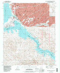
1994 Map of Lake Havasu City South
USGS Topo · Published 1997About this map
Lake Havasu City is the focal point of this 1990s-era geography, showing a community defined by its relationship with the Colorado River and the sprawling waters of Lake Havasu. The most prominent landmark is the relocated London Bridge, which connects the main city to the developed peninsula at Pittsburg Point. The map captures a moment of transition for the local infrastructure, noting the Lake Havasu City Airport (Abandoned) while outlining extensive residential streets and the Lake Havasu Golf & Country Club.
Find a feature on this map
27 named features on this map. Tap any name to fly to it.
Don’t see what you’re looking for? This feature index may not catch every label — zoom into the map to look around manually.
Map Details
Editions of this 1994 Lake Havasu City South Map
This is the sole edition of this map. No revisions or reprints were ever made.
Other maps of this area

1903 · Needles
USGS Topo · 1:125,000

1904 · Needles Special
USGS Topo · 1:125,000

1911 · Parker
USGS Topo · 1:125,000

1927 · Buck Mountains
USGS Topo · 1:62,500

1929 · Buck Mountains
USGS Topo · 1:62,500

1943 · Giers Basin
USGS Topo · 1:62,500

1943 · Topock
USGS Topo · 1:62,500

1943 · Whipple Mts.
USGS Topo · 1:62,500

1950 · Parker Dam Area
USGS Topo · 1:62,500

1950 · Topock
USGS Topo · 1:62,500