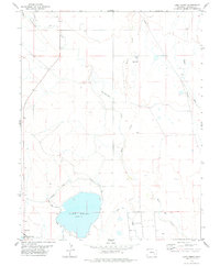
1978 Map of Lake Henry
USGS Topo · Published 1978About this map
Lake Henry, a prominent water body in Crowley County, serves as the focal point for an intricate irrigation system in this high plains landscape. Fed by the Colorado Canal and the Inlet, the lake's water levels are managed through the West Ditch and the Sugar City Lateral. The surrounding terrain is defined by dry watercourses and seasonal drainages, including Horse Creek, Breckenridge Creek, and Black Draw. Local ranching and agricultural operations are evidenced by scattered landmarks such as Faw Wells and a Water Tank positioned on the higher ground overlooking the creek beds. This 1970s survey illustrates a region where water management infrastructure, including the Colorado Canal, dictates the layout of the rural landscape.
Find a feature on this map
14 named features on this map. Tap any name to fly to it.
Don’t see what you’re looking for? This feature index may not catch every label — zoom into the map to look around manually.
Map Details
Editions of this 1978 Lake Henry Map
This is the sole edition of this map. No revisions or reprints were ever made.
Other maps of this area

1891 · Catlin
USGS Topo · 1:125,000

1893 · Catlin
USGS Topo · 1:125,000

1954 · Meredith Hill
USGS Topo · 1:24,000

1954 · Sugar City
USGS Topo · 1:24,000

1954 · Ordway
USGS Topo · 1:24,000

1954 · Lamar
USGS Topo · 1:250,000

1958 · Lamar
USGS Topo · 1:250,000
1977 · The Pinnacles
USGS Topo · 1:24,000
1977 · Box Springs
USGS Topo · 1:24,000
1977 · Todd Point
USGS Topo · 1:24,000