
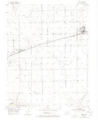
1954 Map of Ordway
USGS Topo · Published 1956About this map
Ordway serves as the primary hub of this high plains agricultural landscape, defined by a complex irrigation network that transformed the prairie. The Missouri Pacific railroad cuts a diagonal line across the terrain, linking the town of Crowley to the regional transport system. This mid-century survey illustrates how water management dictated the local economy, with the Colorado Canal and numerous ditches like the Dayton Lateral and Drescher Lateral feeding the surrounding farmsteads. The presence of the Numa Sch and the Ordway Airport highlights the distribution of community services and infrastructure during the 1950s. To the south, the Arkansas River serves as the natural boundary for the county, while the Lake Meredith Reservoir Outlet Ditch indicates the scale of water diversion efforts necessary for cultivation in this arid environment.
Find a feature on this map
19 named features on this map. Tap any name to fly to it.
Don’t see what you’re looking for? This feature index may not catch every label — zoom into the map to look around manually.
Map Details
Editions of this 1954 Ordway Map
2 editions found
Other maps of this area

1891 · Catlin
USGS Topo · 1:125,000

1893 · Catlin
USGS Topo · 1:125,000

1954 · Olney Springs
USGS Topo · 1:24,000

1954 · Elder
USGS Topo · 1:24,000

1954 · Sugar City
USGS Topo · 1:24,000

1954 · Manzanola
USGS Topo · 1:24,000

1954 · Lamar
USGS Topo · 1:250,000

1955 · Rocky Ford
USGS Topo · 1:24,000

1958 · Lamar
USGS Topo · 1:250,000
1977 · Antelope Mesa
USGS Topo · 1:24,000