
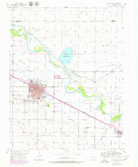
1955 Map of Rocky Ford
USGS Topo · Published 1956About this map
Rocky Ford stands as a dense agricultural and industrial hub along the Arkansas River in the mid-1950s. The town's grid is defined by its proximity to the Atchison Topeka and Santa Fe railroad and a complex network of irrigation infrastructure, including the Fort Lyon Storage Canal and the Rocky Ford Highline Canal. The local economy of the era is clearly visible through the presence of the Sugar Refinery and a Beet Pulp Pit, reflecting the region's historical ties to the sugar beet industry.
Find a feature on this map
29 named features on this map. Tap any name to fly to it.
Don’t see what you’re looking for? This feature index may not catch every label — zoom into the map to look around manually.
Map Details
Editions of this 1955 Rocky Ford Map
2 editions found
Other maps of this area

1891 · Catlin
USGS Topo · 1:125,000

1891 · Timpas
USGS Topo · 1:125,000

1893 · Catlin
USGS Topo · 1:125,000

1894 · Timpas
USGS Topo · 1:125,000

1953 · Cheraw
USGS Topo · 1:24,000

1954 · Meredith Hill
USGS Topo · 1:24,000

1954 · Sugar City
USGS Topo · 1:24,000

1954 · Ordway
USGS Topo · 1:24,000

1954 · Manzanola
USGS Topo · 1:24,000

1954 · Lamar
USGS Topo · 1:250,000