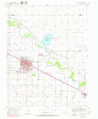
1955 Map of Rocky Ford
USGS Topo · Published 1979About this map
The Arkansas River valley defines this mid-century landscape, where a sophisticated network of irrigation canals supported the region's agricultural industry. The town of Rocky Ford serves as the hub of this system, anchored by the massive Sugar Refinery and the Fairground. To the east, the settlement of Swink and the small siding at Newdale follow the corridor of the Atchison Topeka and Santa Fe railroad, which parallels the river.
Find a feature on this map
37 named features on this map. Tap any name to fly to it.
Don’t see what you’re looking for? This feature index may not catch every label — zoom into the map to look around manually.
Map Details
Editions of this 1955 Rocky Ford Map
2 editions found

Other maps of this area

1891 · Catlin
USGS Topo · 1:125,000

1891 · Timpas
USGS Topo · 1:125,000

1893 · Catlin
USGS Topo · 1:125,000

1894 · Timpas
USGS Topo · 1:125,000

1953 · Cheraw
USGS Topo · 1:24,000

1954 · Meredith Hill
USGS Topo · 1:24,000

1954 · Sugar City
USGS Topo · 1:24,000

1954 · Ordway
USGS Topo · 1:24,000

1954 · Manzanola
USGS Topo · 1:24,000

1954 · Lamar
USGS Topo · 1:250,000