
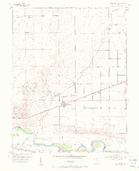
1954 Map of Olney Springs
USGS Topo · Published 1956About this map
Olney Springs serves as the hub of this mid-century high plains landscape, situated at the boundary of Crowley and Otero Counties. The town's lifeblood is revealed through an intricate system of water management, including the Colorado Canal, Catlin Canal, and numerous named laterals such as the Auckland Lateral and Bradbury Lateral. This hydraulic network supports the arid terrain above the Arkansas River, which flows across the southern portion of the sheet near its junction with the Apishapa River.
Find a feature on this map
33 named features on this map. Tap any name to fly to it.
Don’t see what you’re looking for? This feature index may not catch every label — zoom into the map to look around manually.
Map Details
Editions of this 1954 Olney Springs Map
2 editions found
Other maps of this area

1891 · Catlin
USGS Topo · 1:125,000

1891 · Nepesta
USGS Topo · 1:125,000

1893 · Nepesta
USGS Topo · 1:125,000

1893 · Catlin
USGS Topo · 1:125,000

1904 · Nepesta
USGS Topo · 1:125,000

1954 · Elder
USGS Topo · 1:24,000

1954 · Ordway
USGS Topo · 1:24,000

1954 · Manzanola
USGS Topo · 1:24,000

1954 · Lamar
USGS Topo · 1:250,000

1954 · Pueblo
USGS Topo · 1:250,000