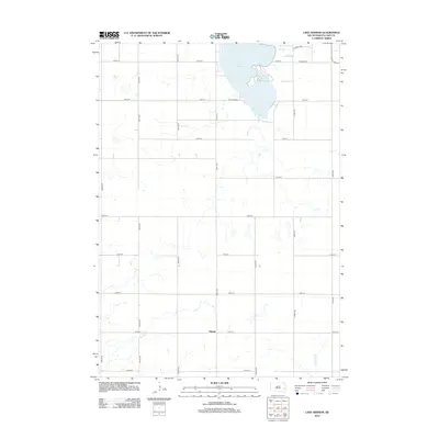
2012 Map of Lake Herman
USGS Topo · Published 2012About this map
Lake Herman and its adjacent Herman Slough dominate the northeastern corner of this landscape, serving as the primary geographical anchor for the surrounding agricultural prairie. The 2012 survey illustrates a well-defined section-line road network typical of the Great Plains, with 451st Ave and 235th St providing the main corridors toward Camp Lakodia on the southern lake shore. Further south, the small settlement of Orland sits at the intersection of 241st St and 451st Ave, positioned between the drainage systems of Silver Cr to the north and N Buffalo Cr to the south. This map details the modern rural infrastructure of Lake County, documenting the persistence of small communities and the systematic land divisions that characterize eastern South Dakota's farming country.
Find a feature on this map
24 named features on this map. Tap any name to fly to it.
Don’t see what you’re looking for? This feature index may not catch every label — zoom into the map to look around manually.
Map Details
Editions of this 2012 Lake Herman Map
This is the sole edition of this map. No revisions or reprints were ever made.
Other maps of this area

1953 · Watertown
USGS Topo · 1:250,000

1955 · Sioux Falls
USGS Topo · 1:250,000

1958 · Sioux Falls
USGS Topo · 1:250,000

1958 · Watertown
USGS Topo · 1:250,000

1968 · Lake Madison
USGS Topo · 1:24,000

1968 · Ramona
USGS Topo · 1:24,000

1968 · Madison
USGS Topo · 1:24,000
1968 · Buffalo Trading Post
USGS Topo · 1:24,000

1968 · Lake Madison SW
USGS Topo · 1:24,000

1968 · Lake Herman
USGS Topo · 1:24,000