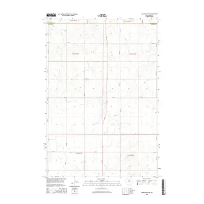
2015 Map of Lake Hurley NE
USGS Topo · Published 2015About this map
Little Cheyenne Creek meanders through this agricultural landscape on the border of Walworth and Potter Counties. The terrain is defined by its Public Land Survey System grid, which dictates the placement of rural section roads like 150th St and 153rd St. For those researching local family history, two small burial grounds are documented: Hanson Cemetery sits in the northern half of the quadrangle, while Appomattox Cemetery is located further south near the section 11 and 12 boundaries of Township 119 North. The sparse distribution of these named landmarks suggests a quiet, pastoral era where small rural communities were centered around these local cemeteries and the seasonal flow of the creek.
Find a feature on this map
17 named features on this map. Tap any name to fly to it.
Don’t see what you’re looking for? This feature index may not catch every label — zoom into the map to look around manually.
Map Details
Editions of this 2015 Lake Hurley NE Map
This is the sole edition of this map. No revisions or reprints were ever made.
Other maps of this area

1953 · McIntosh
USGS Topo · 1:250,000

1954 · Aberdeen
USGS Topo · 1:250,000

1956 · Aberdeen
USGS Topo · 1:250,000

1958 · McIntosh
USGS Topo · 1:250,000

1968 · Akaska SW
USGS Topo · 1:24,000

1968 · Akaska
USGS Topo · 1:24,000

1970 · Steamboat Creek
USGS Topo · 1:24,000

1970 · Lake Hurley
USGS Topo · 1:24,000

1970 · Lake Hurley NE
USGS Topo · 1:24,000
1970 · Lake Hurley SE
USGS Topo · 1:24,000