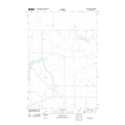
2012 Map of Lake Hurley
USGS Topo · Published 2012About this map
Lake Hurley and the winding course of Little Cheyenne Cr dominate this rural Potter County landscape, illustrating the hydrology of the Missouri River basin. The western edge of the map follows the jagged shoreline of Lake Oahe, a major reservoir formed by the damming of the Missouri. The terrain is marked by a grid of section-line roads, including Co Rd 103 and various numbered streets like 164 St, which define the agricultural divisions of the High Plains. Traces of older transit are visible in the path of Old 212 Rd, showing how the modern road network evolved alongside the existing topography and water bodies. This 2012 survey captures the area as a sparsely populated ranching and farming district, where the presence of large-scale reservoirs has fundamentally altered the natural flow of local creeks.
Find a feature on this map
15 named features on this map. Tap any name to fly to it.
Don’t see what you’re looking for? This feature index may not catch every label — zoom into the map to look around manually.
Map Details
Editions of this 2012 Lake Hurley Map
This is the sole edition of this map. No revisions or reprints were ever made.
Other maps of this area

1953 · McIntosh
USGS Topo · 1:250,000

1954 · Pierre
USGS Topo · 1:250,000

1958 · Pierre
USGS Topo · 1:250,000

1958 · McIntosh
USGS Topo · 1:250,000

1969 · Four Bear Creek
USGS Topo · 1:24,000

1969 · Patch Skin Buttes SE
USGS Topo · 1:24,000

1970 · Steamboat Creek
USGS Topo · 1:24,000

1970 · Lake Hurley
USGS Topo · 1:24,000

1970 · Lake Hurley NE
USGS Topo · 1:24,000

1970 · Agar NW
USGS Topo · 1:24,000