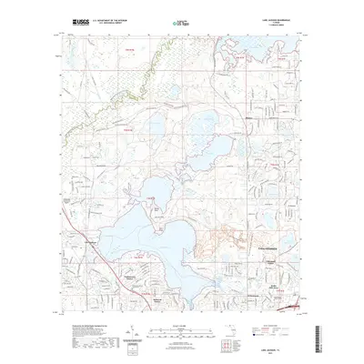
2021 Map of Lake Jackson
USGS Topo · Published 2021About this map
The vast Lake Jackson and the northwestern reaches of Tallahassee dominate this landscape where suburban expansion meets protected parklands and natural waterways. To the north, the terrain is characterized by a series of significant water bodies, including Lake Iamonia, Carr Lake, and Orchard Pond, separated by trails like the Upper Ochlockonee River State Trail. This interface of water and land is further defined by prominent points such as Rollins Point and Brill Point extending into the central lake. Local residential developments like Harbinwood Estates and Bellwood Estates occupy the southern portion of the sheet near the city limits, while family history is preserved at sites like the Tallahassee Memory Gardens Cemetery and the Moore Cemetery. The western edge is bounded by the Ochlockonee River, marking the border between Gadsden and Leon counties, providing a clear view of the region's natural drainage and historical land divisions.
Find a feature on this map
200 named features on this map. Tap any name to fly to it.
Don’t see what you’re looking for? This feature index may not catch every label — zoom into the map to look around manually.
Map Details
Editions of this 2021 Lake Jackson Map
This is the sole edition of this map. No revisions or reprints were ever made.
Other maps of this area

1940 · Tallahassee
USGS Topo · 1:62,500

1942 · Tallahassee
USGS Topo · 1:62,500

1943 · Tallahassee
USGS Topo · 1:62,500

1954 · Lafayette
USGS Topo · 1:24,000

1954 · Tallahassee
USGS Topo · 1:250,000

1956 · Havana North
USGS Topo · 1:24,000

1956 · Calvary
USGS Topo · 1:24,000

1957 · Beachton
USGS Topo · 1:24,000

1959 · Tallahassee
USGS Topo · 1:250,000

1960 · Tallahassee
USGS Topo · 1:250,000