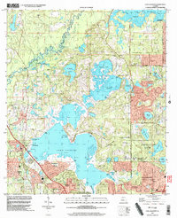
1999 Map of Lake Jackson
USGS Topo · Published 2003About this map
Lake Jackson and the Ochlockonee River dominate this northern Leon County landscape as the suburban reach of Tallahassee expands northward. The map documents a period of significant parkland preservation and residential development, notably around Harbinwood Estates and Bellwood Estates. Cultural and historical sites are well-preserved in the southern portion, including the Lake Jackson Mounds Archaeological State Park and Alfred B Maclay Gardens State Park. To the north, the geography remains defined by a complex of water bodies like Carr Lake, Orchard Pond, and Mallard Pond, which are linked by public access points such as Bull Headley Public Landing. This survey captures the region just as the older rural tracts were being integrated into the city's modern corporate boundaries.
Find a feature on this map
65 named features on this map. Tap any name to fly to it.
Don’t see what you’re looking for? This feature index may not catch every label — zoom into the map to look around manually.
Map Details
Editions of this 1999 Lake Jackson Map
This is the sole edition of this map. No revisions or reprints were ever made.
Other maps of this area

1940 · Tallahassee
USGS Topo · 1:62,500

1942 · Tallahassee
USGS Topo · 1:62,500

1943 · Tallahassee
USGS Topo · 1:62,500

1954 · Lafayette
USGS Topo · 1:24,000

1954 · Tallahassee
USGS Topo · 1:250,000

1956 · Havana North
USGS Topo · 1:24,000

1956 · Calvary
USGS Topo · 1:24,000

1957 · Beachton
USGS Topo · 1:24,000

1959 · Tallahassee
USGS Topo · 1:250,000

1960 · Tallahassee
USGS Topo · 1:250,000