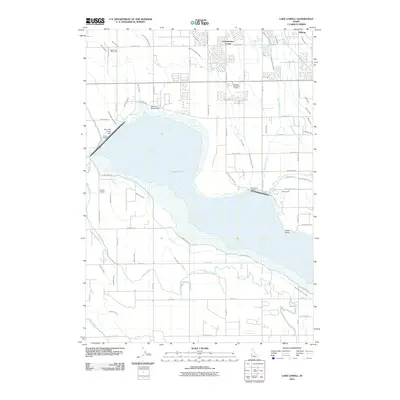
2011 Map of Lake Lowell
USGS Topo · Published 2011About this map
Lake Lowell dominates this Canyon County landscape, its waters contained by a series of engineered structures including Deer Flat-Upper Dam, Deer Flat-Middle Dam, and Deer Flat-Lower Dam. The surrounding terrain is defined by a dense network of irrigation infrastructure essential to Idaho agriculture, featuring prominent arteries like the Phyllis Canal, Mora Canal, and Deer Flat Caldwell Canal. Smaller distributors such as the Messler Lateral and Thacker Lateral reach into the rural blocks. Local landmarks provide social and historical context, from the Sage Acres Race Track in the northwest corner to the Hillcrest Memorial Gardens cemetery near the lake's northern shore. Small settlement clusters such as Underkoflers Corner, Sage Acres, and Midway anchor the grid of country roads, while Gotts Point marks a distinct projection into the eastern reaches of the reservoir.
Find a feature on this map
72 named features on this map. Tap any name to fly to it.
Don’t see what you’re looking for? This feature index may not catch every label — zoom into the map to look around manually.
Map Details
Editions of this 2011 Lake Lowell Map
This is the sole edition of this map. No revisions or reprints were ever made.
Other maps of this area

1892 · Silver City
USGS Topo · 1:125,000

1894 · Silver City
USGS Topo · 1:125,000

1898 · Nampa
USGS Topo · 1:125,000

1898 · Silver City
USGS Topo · 1:125,000

1955 · Boise
USGS Topo · 1:250,000

1957 · Opalene Gulch
USGS Topo · 1:24,000

1957 · Sands Basin
USGS Topo · 1:62,500

1957 · Notus
USGS Topo · 1:24,000

1958 · Boise
USGS Topo · 1:250,000
1958 · Givens Hot Springs
USGS Topo · 1:24,000