1982 Map of Lake Lucero
USGS Topo · Published 1982About this map
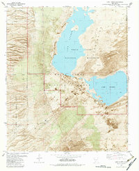
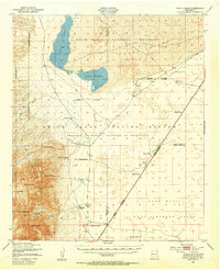
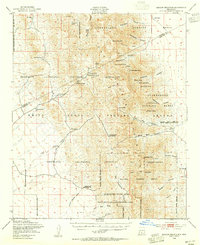
Lake Lucero dominates this Tularosa Basin landscape, sitting within a topographic depression where mineral-rich waters accumulate and evaporate. In the early 1980s, this area served as a critical intersection of federal land management, split between the White Sands National Monument and the White Sands Missile Range. The boundary lines reveal a complex geography where preservation at the San Andres National Wildlife Refuge meets the strategic requirements of the missile range. On the western edge, the terrain rises sharply into the mountains, marked by San Andres Canyon and Ash Canyon. Evidence of human activity and resource extraction is visible through labels for the Apache Site, a Drill Hole, and infrastructure like Mar Water Well No 1 and Mar Water Well No 2, providing a look at how this arid environment was utilized for both military and local needs amidst the constant movement of Shifting Sand.
Find a feature on this map
14 named features on this map. Tap any name to fly to it.
Don’t see what you’re looking for? This feature index may not catch every label — zoom into the map to look around manually.
Map Details
Editions of this 1982 Lake Lucero Map
2 editions found

Other maps of this area

1916 · Tonuco
USGS Topo · 1:125,000

1916 · Point Of Sands
USGS Topo · 1:125,000

1932 · Tonuco
USGS Topo · 1:125,000

1947 · Point Of Sands 2
USGS Topo · 1:62,500
1947 · Lake Lucero
USGS Topo · 1:62,500

1948 · Bear Peak
USGS Topo · 1:62,500
1948 · Kaylor Mountain
USGS Topo · 1:62,500

1948 · Lake Lucero
USGS Topo · 1:24,000

1948 · Lake Lucero SW
USGS Topo · 1:24,000
1948 · Lake Lucero SE
USGS Topo · 1:24,000