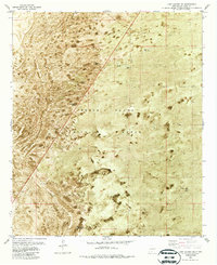
1982 Map of Lake Lucero
USGS Topo · Published 1987About this map
White Sands Missile Range dominates the landscape of this 1982 orthophotomap, where the arid terrain of southern New Mexico is captured through a combination of aerial photography and topographic data. The map reveals the functional infrastructure of this restricted military zone, featuring a Landing Strip, various trails, and isolated designated areas such as Don Site and Lass Site. Water management is critical in this desert environment, evidenced by the presence of Burch Tank, Douzette Tank, and the Thompson Reservoir, which provide rare points of relief across the basin. The inclusion of a Radio Tower and specific landmarks like Tom and G Site points to the specialized communications and testing activity characteristic of the region's mid-to-late 20th-century history.
Find a feature on this map
17 named features on this map. Tap any name to fly to it.
Don’t see what you’re looking for? This feature index may not catch every label — zoom into the map to look around manually.
Map Details
Editions of this 1982 Lake Lucero Map
2 editions found
Other maps of this area

1916 · Tonuco
USGS Topo · 1:125,000

1916 · Point Of Sands
USGS Topo · 1:125,000

1932 · Tonuco
USGS Topo · 1:125,000

1947 · Point Of Sands 2
USGS Topo · 1:62,500

1947 · Lake Lucero
USGS Topo · 1:62,500

1948 · Bear Peak
USGS Topo · 1:62,500

1948 · Kaylor Mountain
USGS Topo · 1:62,500

1948 · Lake Lucero
USGS Topo · 1:24,000

1948 · Lake Lucero SW
USGS Topo · 1:24,000

1948 · Lake Lucero SE
USGS Topo · 1:24,000